
Page 33 - January 15 Volume 19 Number 1
P. 33
• As relative humidity increases CCN become “wetted” and visibility becomes obstructed.
• A relatively clean environment (fewer CCN) will typically increase the drop size.
• Larger drops represent a greater icing hazard.
• Where are the clean environments? Over large bodies of water, over snow covered ground, in clouds above temperature inversions, near the tops of clouds.
• “Cloud top temperatures warmer than -12°C means the cloud is likely dominated by supercooled liquid water.”
• “The only way to guarantee there will be no ice [above the freezing level] is to fly at colder than 40° below [zero],” Scott advises.
Supercooled Liquid Droplets
Even airplanes certificated for flight into icing conditions (so-called “FIKI” approval) are not approved nor permitted to operate in Supercooled Liquid Droplet (SLD) conditions.
SLD Conditions: An environment containing drops with a median volumetric diameter (MVD) greater than 50 microns.
1,000 microns = 1 millimeter
50 microns = Half the width of a human hair
If you can see water droplets or distinguish drops in the mist on the windscreen or leading edges before takeoff, or as you fly through clouds or precipitation, it’s SLD conditions. Flight Into Icing Conditions approval is not valid in such an environment; FIKI equipment will not protect you. The worst SLD condition is freezing rain. In freezing rain, the rate of ice accumulation is so great that no amount of ice protection equipment is going to prevent the dangerous build-up of aerodynamics-destroying ice in very short order.
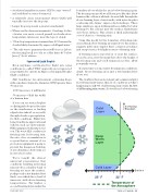
We’re taught the almost universal presentation that conditions resulting in freezing rain involves a shallow band of freezing air near the surface, perhaps only a few hundred feet thick, over which lies a band of warm air, with above-freezing temperatures. Far higher, a second freezing layer marks the
boundary above which the air is below freezing again. The freezing rain model we all learn goes like this: Snow forms in the cold air at altitude. As snow falls through the above-freezing layer of air it melts, with water droplets coalescing into larger, supercooled raindrops. These large raindrops, upon striking surfaces chilled to below freezing by the cold air near the surface, flash-freeze onto those surfaces. This creates a thick and irregular coat of clear ice—freezing rain.
Using this model for the formation of freezing rain, one in which above-freezing air is just above the surface, suggests pilots may employ these common avoidance and escape tactics for flight in areas of freezing rain:
If freezing rain is reported at or near the surface, cross the area a few thousand feet above the height of the freezing rain and you’ll remain in ice-free, albeit potentially wet air.
If at any time you encounter freezing rain conditions, climb. Above-freezing air is just a few hundred feet above you.
The trouble is that, meteorologist and commercial pilot Scott Dennstaedt warns, this set of conditions is what’s happening in only 8% of all freezing rain events. In 92% of all freezing rain events, Scott tells us, below-freezing
Cold Layer
Deep Warm Layer
Cold Layer 25° F
Increasing Elevation
Surface
32° F
Temperature of the Atmosphere
JANUARY 2015
TWIN & TURBINE • 31
