
Page 17 - February 2016
P. 17
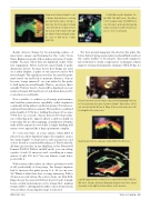
Flying west-northwest along the coast of Alaska. Evidently there’s a strong west wind at the surface. Strong re- turns like this from water normally comes from the face of waves. Those black areas in the terrain to the right are valleys behind mountain peaks. As seen in WX mode, Collins WXR 700.La Plata River mouth, Argentina. Col- lins WXR 700, MAP mode. This with a 1970’s designed radar. The WXR 700 is one of the least capable ground mapping radars you may encounter. However, as you see here, it’s adequate.Radar detects things by broadcasting pulses of microwave energy and listening for the “echo” from them. Engineers speak of those pulses in terms of “pulse widths” because of how they are displayed on his or her test equipment. Pilots, however, must think of pulse dimension in feet, because feet is how things are seen on a radar display. A pulse of one microsecond is 984 feet in length. The significance is that, because the pulse must travel out and back to measure distance, objects become “range smeared” on your radar by the pulse to half again its actual length. That is, an object that’s actually 984 feet front to back will be displayed on your radar as being 1,476 feet front to back when detected by a one-microsecond pulse.Now consider, to achieve good range performance and weather penetration capability, radar engineers commonly string pulses together in groups. For instance, a string of four pulses is common. The result is a combined pulse length of 3,936 feet. Adding the smear, it becomes 5,904 feet. As a result, objects detected by that radar, say a thin flag pole, appear almost a mile in depth on your radar. Not good for mapping. A small river 3/4 miles wide will be smeared over totally. A single building will smear out to appear like a huge apartment complex.To overcome that, on some radars, when MAP is selected on a short displayed range, the engineer causes the “pulse length” to drop back to only one microsecond or less. Detail is considerably enhanced. That’s why the all-time-great radar, in my thinking, is the Honeywell Primus 700/701. With it, in MAP mode, you can call up a pulse of only 0.1 microsecond – resulting in a range smear of only 150 feet! You can almost count fence posts with it.With certain other radars, in order to get them to work at all, particularly at long range, the design engineer had to increase the pulse group to 6, 10, in one case 28! Think of what that does to range smearing. With a 28-microsecond string, the echoes from our thin little flag pole now becomes 41,000 feet front to back! A single house on that radar smears out to a huge blob, making it impossible to distinguish weather echoes from terrain objects when a long display range is selected.For best ground mapping, the shorter the pulse the better. Before buying a new radar you should find out about the “pulse widths” it broadcasts. (Recently engineers have switched to “pulse compression” techniques, which improve terrain detail greatly; Garmin’s GWX 70 has it.)Florida Coast from over the Glades. Any problem Navigating from here to Fort Lauderdale Executive, Key West, Bimini? Taken with a 1970’s era, low end, Bendix, WX mode. Many of the ancient radars are better for navigation then newer ones.New Orleans from the southeast. Collins WXR 700. WX mode.Lake Michigan from the northwest on an early (1980) Collins TWX 850. WX mode. Chicago, Glenview, Waukegan along the near shore. Gary’s steel mills on the right tip. Benton Harbor on the far shore.FEBRUARY 2016TWIN & TURBINE • 15
