
Page 32 - Volume 15 Number 8
P. 32
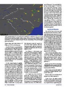
When thunderstorms are expected to be scattered or isolated as they are in this XM-delivered satellite weather radar image, don’t expect to see thunder added to any of the TAFs in this area until one of these cells is knocking on the terminal area’s door. Of course, that forecast for thunder would likely be issued through a quick amendment.
strict “directive” that says PROB30 groups cannot appear in the first nine hours of the forecast. In fact, their software checks all outgoing forecasts and flags those forecasts that do not meet this directive. By the way, in the United States only PROB30 groups are allowed in TAFs constructed by the NWS...PROB40 was banned from NWS TAFs more than a decade ago. However, you may still see PROB40 in TAFs for military airports. Many WFOs do not use PROB30 in a TAF even if a 30 percent chance of convection is expected after the first nine hours of the forecast period.
Area Forecast Discussion
One of the best tools is to read the area forecast discussion (AFD). After the forecaster issues his or her TAFs, the same person is responsible for developing the AFD. Every AFD has an aviation section (see http:// aviationweather.gov/products/afd/) to allow the forecaster to discuss the weather challenges and express his or her uncertainty. For example, in the Charlotte forecast we looked at originally (FM091600 11012G18KT P6SM VCSH BKN070), the forecaster at the Greenville-Spartanburg WFO suggested the following...
“SCATTERED SHOWERS AND A PERHAPS A TSTM...ARE EXPECTED ACRS THE NC PIEDMONT FROM THE AFTERNOON UNTIL EARLY EVENING AND WILL CARRY VCSH FOR NOW TO COVER THAT THREAT.”
In fact, at 1813 UTC on that day, Charlotte/Douglas airport reported a thunderstorm in the terminal area based on this METAR...
KCLT 271813Z 07003KT 10SM TS SCT040CB BKN090 BKN200 16/09 A2956 RMK AO2
TSB13 OCNL LTGIC TS SE-SW-W MOVG E CB NW-N MOVG E.
I live about 30 miles south- southeast of the airport and we had a severe thunderstorm roll through my neighborhood spattering pea-
Notice there isn’t any mention of TSRA or VCTS in this forecast.
Another favorite is to just include VCSH (showers in the vicinity of the terminal area) or –SHRA (light rain showers in the terminal area). In the case of –SHRA or VCSH, the cloud group may or may not contain CB in the cloud group such as FM191600 33005KT P6SM VCSH BKN060. What the forecaster adds or omits is conveying his or her confidence at that moment.
As the event begins to unfold, future scheduled TAFs will likely change as forecaster confidence increases or decreases. They may add VCTS such as FM192200 30006KT P6SM VCTS BKN050CB. Keep in mind that guidelines can vary somewhat from one WFO to the next. For example, the Charleston, S.C., WFO rarely uses VCTS in their terminal forecasts based on their homegrown guidelines. Forecasters can also include a TEMPO group such as TEMPO 1919/1923 3SM TSRA OVC030CB. In many cases,
30 • TWIN & TURBINE
this forecast might be issued or amended after you’ve already departed; that’s why it’s important to always get updates to the forecast while en route.
In addition, a forecaster can amend the TAF at any time to reflect a greater degree of confidence. That’s typically the scenario when the expected convection is within the first six-hour period after a TAF is issued. It is not unusual to see a TAF go from – SHRA BKN050 to VCSH BKN050CB to VCTS BKN050CB to –TSRA BKN050CB all within a two- or three-hour period. Pilots may see this as the forecaster just covering his or her mistakes when, in fact, it is just a way for the forecaster to express his or her confidence through the forecast period.
You might have been wondering about the PROB30 group? If the forecaster is really uncertain about convection, why not just add this to the terminal forecast? Even though forecasters are encouraged to “give it their best shot,” the NWS has a
AUGUST 2011
