
Page 31 - Volume 15 Number 8
P. 31
When a weather system associated with a front or developing area of low pressure exhibits strong atmospheric dynamics or forcing, then the forecaster might be more certain of the timing and impact of a convective event within the terminal area. In that case, he or she may identify the threat specifically with –TSRA or VCTS (thunderstorms in the vicinity of the terminal area). These dynamic situations do not describe the normal convective scenario throughout the year; most convective events have a much greater degree of uncertainty. This is especially true for a forecast of convection more than four to six hours in the future.
What are the forecaster’s options when there is a fair amount of convective uncertainty? Most local WFOs have developed their own local forecast rules or guidelines based on specific forecast criteria. Forecasters will apply these rules based on their professional judgment for airports serviced by a TAF that fall within their county warning areas (CWAs).
Every WFO is essentially allowed to develop, manage and apply these homegrown guidelines as they see fit. And there’s absolutely no requirement or inclination to publish them. In other words, pilots have no way of appreciating what a forecaster is trying to convey simply by reading the TAF. Moreover, guidelines may change as the forecast philosophy changes at that particular WFO.
So, what are some of these guidelines? Well, the forecaster could simply leave it out any mention of a convective threat and let the next forecaster on the short-term desk deal with the issue. This may be the preferred method when the convective event isn’t expected for six or more hours. They may simply use CB (for cumulonimbus clouds) for the lowest layer of clouds. For example, you may see FM102000 26009KT P6SM SCT025CB BKN060.
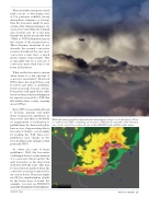
While the timing might be adjusted with amendments, there’s no doubt that you’ll see a couple dozen TAFs containing a forecast for TSRA far downwind of this dynamic mesoscale convective system shown in this XM-delivered satellite radar image.
AUGUST 2011
TWIN & TURBINE • 29
