
Page 37 - Mar17ABS
P. 37
ForeFlight Adds New Features to Latest Updates
ForeFlight released the first major update for 2017, version 8.3, which brings a collection of new features
to the app. The update includes new weather maps, new night settings and logbook enhancements.
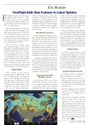
The latest addition has a new satellite weather overlay for the Maps screen that weather geeks will love. This new Color IR Satellite option in the map overlay drop-down menu. This is a second satellite layer that complements the existing satellite overlay, which is now called Enhanced Satellite.
This worldwide weather layer uses infrared images to show cloud temperatures, which typically decrease with altitude (the blue areas on the layer are the coldest). This can be useful when f lying during the colder months to help identify areas that contain supercooled liquid water and possible icing conditions. This phenomenon is likely to be present in the yellow and green areas, which are just warm enough to sustain supercooled water droplets.
Night Flight
While setting up the iPad in preparation for a night f light, there are new night settings in the maps and plates section of the app. When viewing the map settings, a new option is at the top called “Invert Chart Colors.” This will change any of the lighter colors on IFR en route chart or sectional to a dark color, and change black text to
white, to help maintain a dark cabin and reduce eyestrain. When viewing the plates section of the app you’ll see a similar option at the top left of the screen, called Invert Plate Colors. This will apply the same color shift to approach plates and airport diagrams for improved night viewing.
IFR Climb Procedures
For IFR departures, the SID procedures define required climb gradients in feet per nautical mile, and then it’s up to the pilot to determine that his or her airplane can meet this performance minimum based its capabilities that day. During flight planning, we use this ft./nm requirement and planned groundspeed to determine the required climb rate in feet per minute, since that’s the number we can relate to while flying.
ForeFlight can help shed more light on how the climb is progressing with a new Climb Gradient Instrument on the maps page. This uses GPS, groundspeed, and vertical speed information to display the climb gradient in feet per nautical mile, allowing the pilot to monitor the climb performance in real time.
Expanded SiriusXM Weather Layers
Pilots f lying with the new Sirius XM SXAR1 aviation receiver have two new map overlay layers to display on the map in flight: Echo Tops and Cloud Tops. The cloud tops layer includes
a slider at the bottom right of the map screen that allows the pilot to filter out clouds at lower altitudes. Tops above 25,000 ft. MSL are color-coded using blue, orange and red to visually enhance the highest tops. Tops below 25,000 ft., are shown as simple shades of gray.
The echo tops layer shows a graphical view of the highest altitude where ground- based radar detects precipitation returns above the 18dBz intensity threshold. The 18dBZ is normally shown as dark blue on a normal radar return. This represents the core of the precipitation in a storm or weather system and can be used to help determine the intensity of the system.
Arrival Alerts
To reduce head-down time in the cockpit while preparing for arrival, ForeFlight will display the weather frequency (ATIS, ASOS or AWOS) for the destination airport when 20 miles out in a pop-up message on the screen. The alert includes spoken audio of the weather frequency and it will remain on the screen until the pilot taps it.
Logbook Enhancements
ForeFlight continues to enhance the f light logging process, including:
• Recent airplanes: when you go to add a specific aircraft to a log entry, ForeFlight will automatically show the most recently used aircraft N#s at the top of the list.
• Instrumentapproaches:thelogbook autofills the destination airport and shows a list of approaches for quick entry.
En Route
• Add currency tracking for multiple aircraft types: The currency summary will now track day and night currency by aircraft type, which is useful for those who need to maintain a certain level of currency in a specific •type of aircraft. Tap “add currency summary” from the main logbook screen, select the new option “aircraft type currency” and choose the aircraft types you’d like to track. T&T
TWIN & TURBINE • 35
March 2017
