
Page 21 - Volume 18 Number 8
P. 21
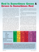
Red Is Sometimes Green & Green Is Sometimes Redradar engineers settled for showing them as three distinct intensities of green, which they labeled 1, 2 and 3. No internal gradients to give pilots clues to the severity of a storm were included, just three bands of green. In doing so, they totally ignored a very critical fact that Jean Lee and Jim Cook had discovered, and which was stated prominently in Lee’s original 1964 report; “It should be noted that these data relate to whole storms. The maximum turbulence encountered is not necessarily in the area of maximum radar reflectivity.”In spite of that clear statement, when the state-of- the-art advanced to color displays, the manufacturers ignored it. They’ve given us green, yellow and red, which they still call 1, 2 and 3, those colors clearly implying that green is go, yellow is caution, and red is no-go. Had they paid careful attention to what the scientists said, they would have given us only green in all parts of an echo in which the reflectivity is low. Where the reflectivity is moderate, echoes should be all yellow and yellow only. Where the reflectivity is in the red range of reflectivity, echoes should be all red. Only then would pilots understand that the hazards from a thunderstorm are not just in the red; they are in the entire echo, as Lee said. In truth, red-level hazards may exist anywhere in the black surrounding an echo with red in it.It must be emphasized; If a thunderstorm echo has red in it anywhere, in your mind even the green and yellow parts of it must be considered level red in hazard potential.That takes care of the headline statement that green is sometimes red. Now, what about red sometimes being green? That’s in the research data and backed up by common experience.When you see red on your radar, there’s about a 70% chance that it’s not red in hazard potential. Check the hazards chart. Very often it’s only an airmass shower. That certainly doesn’t mean you can punch into red echoes without risk, but if it’s just Level 1 red, what are the risks? First, it’s a low-altitude risk. You are not likely to encounter an echo that’s red from bottom to top that extends to 30,000 feet and above. At low level, research data indicates you might experience one severe upset in flying through 20 echoes that are barely red. Certainly don’t go out and try to prove that statement, but flying very close to them, in the clear, presents an acceptable risk.Now, here’s the kicker; modern radar displays often show us red that’s not even a thunderstorm. Stratiform rain will sometime paint red. To be a bona fide thunderstorm, there has to be lightning and thunder. Most of what we think are thunderstorms, because they% Chance of Turbulence L ightModerate Severe ExtremeDamaging Size Hail Risk Rain type50 knot Gust PotentialLevel 1100% To 18% 0%0% None Light LowLevel 2100%18 to 40%0 to .25% 0%None Moderate ModerateLevel 3100%40 to 65% .25 to 3.5%0%0 to 18% Heavy HighLevel 4100%65 to 80% 3.5 to 11% 0 to 3%18 to 23% VeryHeavy 50 knots+Level 5100%80 to 10%0 11 to 37% 3 to 12% >23% Intense 50 knots+Level 6100% 100%37 to 50% 12 to 23% >33%Extreme 50 knots+STORM HAZARDS IN LEVELS — In earlier years storm hazards were given in six VIP values and pilots understood that a VIP 4 is more dangerous than a VIP 3; a VIP 5 is an absolute no-no. Then, as mentioned, back in 2006, bureaucrats decided, for reasons only bureaucrats can understand, that pilots don’t need information that precise. The absolute VIP levels were thrown out and abstract words “Light”, “Moderate”, “Heavy” and “Extreme” were substituted. Now, pilots must understand that “Heavy” refers to both VIP 3 and 4. But as you see in the data, there’s a significant difference in turbulence and hail risks between Levels 3 and 4. And note the extreme difference between VIP 5 and 6. Is that important to you?AUGUST 2014TWIN & TURBINE • 19
