
Page 33 - OCT 19 TNT
P. 33
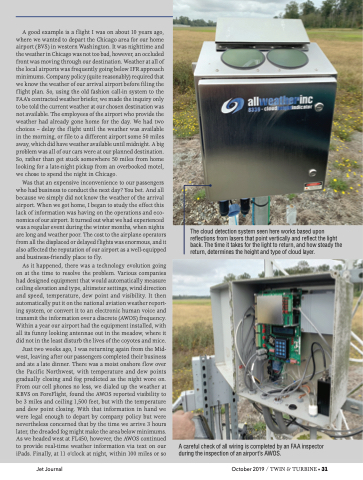
A good example is a flight I was on about 10 years ago, where we wanted to depart the Chicago area for our home airport (BVS) in western Washington. It was nighttime and the weather in Chicago was not too bad, however, an occluded front was moving through our destination. Weather at all of the local airports was frequently going below IFR approach minimums. Company policy (quite reasonably) required that we know the weather of our arrival airport before filing the flight plan. So, using the old fashion call-in system to the FAA’s contracted weather briefer, we made the inquiry only to be told the current weather at our chosen destination was not available. The employees of the airport who provide the weather had already gone home for the day. We had two choices – delay the flight until the weather was available in the morning, or file to a different airport some 50 miles away, which did have weather available until midnight. A big problem was all of our cars were at our planned destination. So, rather than get stuck somewhere 50 miles from home looking for a late-night pickup from an overbooked motel, we chose to spend the night in Chicago. Was that an expensive inconvenience to our passengers who had business to conduct the next day? You bet. And all because we simply did not know the weather of the arrival airport. When we got home, I began to study the effect this lack of information was having on the operations and eco- nomics of our airport. It turned out what we had experienced was a regular event during the winter months, when nights are long and weather poor. The cost to the airplane operators from all the displaced or delayed flights was enormous, and it also affected the reputation of our airport as a well-equipped and business-friendly place to fly. As it happened, there was a technology evolution going on at the time to resolve the problem. Various companies had designed equipment that would automatically measure ceiling elevation and type, altimeter settings, wind direction and speed, temperature, dew point and visibility. It then automatically put it on the national aviation weather report- ing system, or convert it to an electronic human voice and transmit the information over a discrete (AWOS) frequency. Within a year our airport had the equipment installed, with all its funny looking antennae out in the meadow, where it did not in the least disturb the lives of the coyotes and mice. Just two weeks ago, I was returning again from the Mid- west, leaving after our passengers completed their business and ate a late dinner. There was a moist onshore flow over the Pacific Northwest, with temperature and dew points gradually closing and fog predicted as the night wore on. From our cell phones no less, we dialed up the weather at KBVS on ForeFlight, found the AWOS reported visibility to be 3 miles and ceiling 1,500 feet, but with the temperature and dew point closing. With that information in hand we were legal enough to depart by company policy but were nevertheless concerned that by the time we arrive 3 hours later, the dreaded fog might make the area below minimums. As we headed west at FL450, however, the AWOS continued to provide real-time weather information via text on our iPads. Finally, at 11 o’clock at night, within 100 miles or so The cloud detection system seen here works based upon reflections from lasers that point vertically and reflect the light back. The time it takes for the light to return, and how steady the return, determines the height and type of cloud layer. A careful check of all wiring is completed by an FAA inspector during the inspection of an airport’s AWOS. Jet Journal October 2019 / TWIN & TURBINE • 31
