
Page 24 - OCT 19 TNT
P. 24
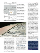
Image Courtesy of Hughes Aerospace PAC, 20 JUN 2019 to 15 AUG 2019 PAC, 20 JUN 2019 to 15 AUG 2019 A 3-D map from a site inspection in Calexico, California. surveys to local planning documents. All procedure designs then require a detailed on-site survey. After the initial design, and coordination with the FAA and other agencies, the procedures must then be test f lown. Hughes Aerospace uses their own Piper Meridian and Robinson R66 as the test platforms, flying the approaches to verify they meet requirements. Once the testing is complete and the procedure approved, Hughes coordinates the publication of the data in the databases, and in the case of private operators, the issuance of the full-color geo-referenced procedure. In order for the procedures to be ac- tive, they must be monitored daily, in- cluding managing the NOTAM service for any changes or variation in service levels. For the majority of approaches that are managed by the FAA, it is their responsibility. For those custom designed for private operators, Hughes Aerospace provides these services. Behind the Scenes Look I recently accompanied Chris on a site inspection for a heliport in Calexico, California – only a few miles from the airport (KCXL) and a stone’s throw from the United States/Mexico border. Chris 22 • TWIN & TURBINE / October 2019 Chris Baur with Hughes Aerospace was instrumental in the design of a public complex RF approach at Pohnpei International (PTPN) in the Federated States of Micronesia that includes radial-to-fix segments on both the final and missed approach portions of the RNP RWY 9 procedure. and his team already completed initial design work remotely, and the mission this visit was to confirm obstacles and obtain the most accurate data on the helipad and surrounding area. We flew from Montgomery Field (KMYF) to Calexico in my Eclipse 500 for the site evaluation. The initial ground survey included mapping the obstructions in the local area with high precision, including their latitude and longitude as well as height. Next was the inspection of the landing site itself. Chris made precise measurements of the helipad, then proceeded to use a small UAV to map the location in detail. I previously owned a photogramme- try company and it was fascinating to see Chris utilize the latest generation of high-resolution technology. The UAV was the perfect aerial platform for this work, flying a precise pattern to assist Chris and his team with creating an accurate 3-D map of the heliport and surrounding areas. This data can then be combined with their other sources to develop the precise paths for the instrument proce- dures. Each site offers new challenges. This one, in particular, had the Mexico border, large communications towers, as well as buildings near the helipad. Hughes Aerospace will take this data to design the instrument approach and departure procedures for their customer. And the work won’t stop after the FAA approval since they must monitor and maintain the procedures for as long as they are active. The next time you are briefing for your instrument approach, or review- ing a departure or arrival procedure, remember that aviation professionals created each one of those altitudes, head- ings, speeds and notes with an attention to detail – and one focus – safety. After 11,000 hours of pilot- ing more than 90 aircraft models, Rich Pickett still has a passion for f lying. Rich holds an ATP, CFII SME, SES, glider li- censes, and type ratings in the L29, L39, Citation 500/510s/525s, Eclipse 500S and DA10. His company, Per- sonal Wings, provides training, mentoring and aircraft services. You can contact Rich at rich@person- alwings.com.
