
Page 13 - TNTMay18
P. 13
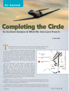
Jet Journal
Completing the Circle
An Accident Analysis & What We Can Learn From It.
The May 2017 crash of a Learjet 35 at New Jersey’s Teterboro Airport has much to teach us regardless of what we fly. The National Transportation Safety Board reports:
A Gates Learjet 35A departed controlled flight while on a circling approach to Runway 1 at the Teterboro Airport (TEB), Teterboro, New Jersey, and impacted a commercial building and parking lot. The airplane was on a Part 91 positioning flight and was destroyed by impact forces and post-crash fire. The captain and first officer died; no one on the ground was injured. Visual meteorological conditions prevailed. The flight departed from Philadelphia, PA, about 1504 and was destined for TEB. The accident flight was the crewmembers’ third flight of the day.
The IFR f light plan to TEB planned a 28-minute f light at Flight Level 270. After departure about 1504 (local time), the f light was cleared to climb to 4,000 feet. The f light reached a maximum altitude of 4,000 feet MSL. About 1515, the f light was cleared to descend to 3,000 feet. The New York Terminal Radar Approach Control (TRACON) cleared the flight for the TEB ILS Runway6Approach,circletolandRunway1.TRACONinstructedthef light contact TEB Tower about nine miles from the airport; however, the flight did not check onto the tower’s frequency until four miles from the airport. ATC cleared the f light to land on Runway 1 and issued the TEB winds of 320 degrees at 16 knots, gusting to 32 knots.
The flight did not start its right circling turn until it was less than 1 mile from the approach end of Runway 6. According to the tower, aircraft typically start the right turn at the final approach fix, which is located 3.8 nm from the approach end of Runway 6.
A TEB controller observed the airplane bank hard to the right and he could see the belly of the airplane with the wings almost perpendicular to the ground. The airplane then appeared to level out for
by Tom Turner
May 2018
TWIN & TURBINE • 11
Wind 320 16G32
Approximate intended path
Approximate point of impact
PHOTO COURTESY OF PAUL BOWEN PHOTOGRAPHY
